|
 LatLon,
(GMT) 02:28:34 Kamis, 11 November 2010)
LatLon,
(GMT) 02:28:34 Kamis, 11 November 2010)
| |
Florian, could you write down the coordinate of "Desa Yensawai", please?
|
|
Stefendy,
(GMT) 09:42:52 Kamis, 11 November 2010)
| |
Waduh bahasa inggris cekak.....
yang di maksud di S0°48'11.0" E130°40'40.8" om latlon ....., lantas yang dipertanyakan maksudnya gimana ya gak mudeng saya, apakah poin tersebut berada di atas laut? kalo ya memang benar point tersebut diatas laut karena itu adalah point pelabuhan
|
|
Florian,
(GMT) 14:38:35 Sabtu, 13 November 2010)
| |
Terima kasih untuk jawaban!
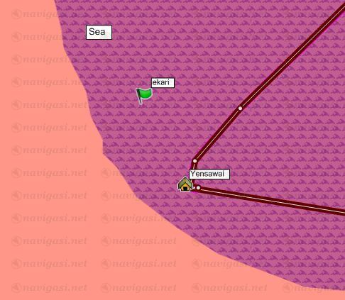
Koordinasi di Yensawai adalah S0 48 17.0 E130 40 44.3.
ekari: Silakan lihat attachement.
Mungkin point-point saya hanya tidak tepat karena GPS device saya tidak menyambung di kurung banyak satellites?
Di Jakarta point saya tepat sekali.
Salam hangat!
 | |  | |  | | |
Pulau Batanta di Raja Ampat | |  | |  |
|
|
LatLon,
(GMT) 15:21:25 Sabtu, 13 November 2010)
| |
Sepertinya Oom Ekari menggambarkan garis pantainya adalah dimulai dari tumbuhnya tanaman keras/hijau bukan daerah yang berpasir dimana desa Yensawai berada.
Mungkin pertimbangannya adalah daerah pasang-surut air laut (tide) sehingga digambarkan demikian.
Tidak ada yang salah dengan Map Datum saya pikir. Dan sinyl GPS yang diperoleh pastilah sangat kuat. 
Ngomong-ngomong bangunan pada titik S0.805782 E130.679443 berupa apa? Bisa jadi POI tuh...
|
|
Florian,
(GMT) 08:58:55 Kamis, 18 November 2010)
| |
Hello, and thanks for the answer once again.
Attached you'll find another screenshot, with the coordinates whicht LatLon gave me. Looks good so far, what is that POI?
Salam hangat,
Florian
|
|
Stefendy,
(GMT) 13:56:42 Kamis, 18 November 2010)
| |
correct yes, like latlon om spell out members coastline not in picture correctly at sand boundary in coast, remember sea water which is ebb and tide, become nothing wrong that datum map goodness or Florian gps.
to be both of location wrong island poi it is true, we will correction. but for the map of um island land have correctness.
sory for my no good english
benar gak nulis inggrisnya? 
|
|
Buyung Akram,
(GMT) 17:34:49 Kamis, 18 November 2010)
| |
Florian:
I think this problem occurs because we are using source map with less accuracy. We don't have enough time to redraw beach/coastline in all indonesia region. Indonesia have more than 10000 island with total coastline larger than 95000 km,
We focus to update street map, currently, but hopefully we can fix our map base on your this report (only) for next release => Desember 17, 2010.
@Ekari: sebaiknya diperbaiki aja garis pantai didaerah yang bermasalah tersebut. Tidak perlu seluruhnya, kecuali Bos benar-benar punya waktu luang dan mau mengerjakannya 
|
|
Buyung Akram,
(GMT) 17:36:46 Kamis, 18 November 2010)
| |
@Florian: Btw, do you have some photo/scenic view for Raja Ampat ? Can you share with us in this forum ?
|
|
www.ukurtanah.web.id,
(GMT) 15:03:54 Jumat, 19 November 2010)
| |
Florian: You should buy a GPS antenna, so your GPS will not have a trouble in signaL... okay...hehehehe
|
|
www.ukurtanah.web.id,
(GMT) 15:05:40 Jumat, 19 November 2010)
| |
then u can modified ur coordinat / datum in setup... wkkkkk
|
|
Isra,
(GMT) 18:46:14 Jumat, 19 November 2010)
| |
I think there is not a problem with the datum or satellite signal reception on your GPS unit, and I think mapdevelopers will soon fix that all.
|
|
Stefendy,
(GMT) 14:49:25 Senin, 22 November 2010)
| |
roger that om Isra..., corected in progress
|
|
Florian,
(GMT) 12:12:35 Selasa, 23 November 2010)
| |
Terima kasih untuk itu upaya kalian dan jawab di sini!
@Buyung Akram: I have many pictures online in my blog:
http://flodonesia.tumblr.com
Thanks, I'm looking forward to the next peta-update.
Sampai jumpa!
| | | | 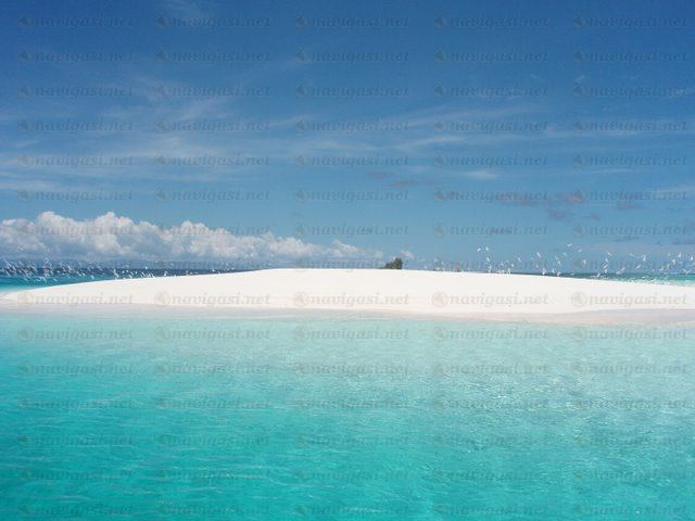 | | |
Pulau Kri dekat desa Yensawai | | | | |
|
|
Boedi,
(GMT) 12:16:33 Selasa, 23 November 2010)
| |
Whuuuui...Paradise Island....Nice View
|


 terlebih dahulu sebelum memberi tanggapan.